A high-impact flood event is taking shape for the New York City area as a coastal storm moves in overnight and threatens to dump prolific amounts of rain Friday.
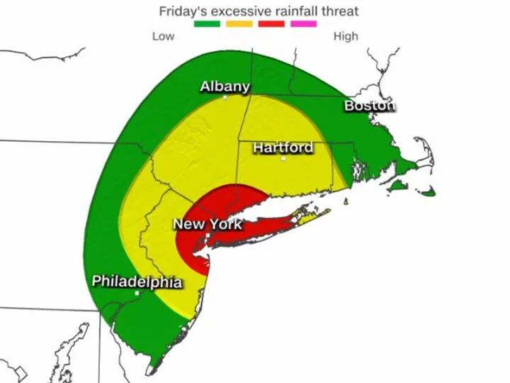
Millions of people in the New York tri-state area face a Level 3 of 4 "moderate" risk for flash flooding Friday, the National Weather Service warned. Intense rainfall rates topping 1 inch an hour are possible throughout the day. Rainfall that intense could cause serious flash flooding on roads and even in subway stations.
The rain will begin for many starting Thursday night, peaking on Friday and Friday night.
New York City Emergency Management issued a travel advisory starting at 4 a.m. Friday through 6 a.m. Saturday, warning of potentially "widespread travel impacts" during the Friday morning commute.
"New York City will be under a flood watch starting tomorrow and we urge New Yorkers to prepare for heavy rain and potential flooding throughout Friday and Saturday morning," NYC Emergency Management Commissioner Zach Iscol said. "All New Yorkers need to exercise caution. If you must travel, consider using public transportation and allow for extra travel time, and if you must drive, do not enter flooded roadways."
Iscol also warned of potential basement flooding, something that proved particularly deadly in the area when Hurricane Ida's remnants wrung out epic amounts of rain two years ago.
Widespread rainfall totals between 2 and 4 inches are expected, but those totals could climb to between 5 and 8 inches in spots where particularly intense bands of rain set up and linger.
The bull's-eye for the worst rain is from central New Jersey northward through Manhattan and Long Island and into southern Connecticut and the Hudson Valley.
Flooding could happen even in areas that only receive one inch of rain, since the ground is already saturated across many areas of the Northeast from recent heavy rainfall. At least two inches of rain has fallen over the last seven days from Virginia through Massachusetts, with some areas picking up over four inches.
The system will be very slow to exit the region this weekend, so more rain is expected on Saturday. The sun finally returns in full force on Sunday as rainfall-limiting high pressure returns to the Northeast and mid-Atlantic.
A supermoon coastal flood threat
Another factor may exacerbate flooding across the Northeast and mid-Atlantic -- a supermoon.
The fourth and final supermoon of 2023 will occur Friday morning, creating more extreme tidal cycles that could increase the flood potential in communities along the East Coast.
As a result, coastal flood advisories extend more than 300 miles from Bridgeport, Connecticut, through Virginia Beach.
Up to one foot of inundation above ground level is expected in low-lying areas near shorelines and tidal waterways. The weather service warns some partial or full road closures are possible.
Rip currents and very high surf are another concern. At least 76 people have died in rip currents so far this year, NOAA data shows.